Winter Storm WATCH Tuesday-Wednesday for the Quad Cities

More winter weather could impact the Quad Cities Tuesday afternoon into early Wednesday morning, which will put the Quad Cities under a Winter Storm Watch.
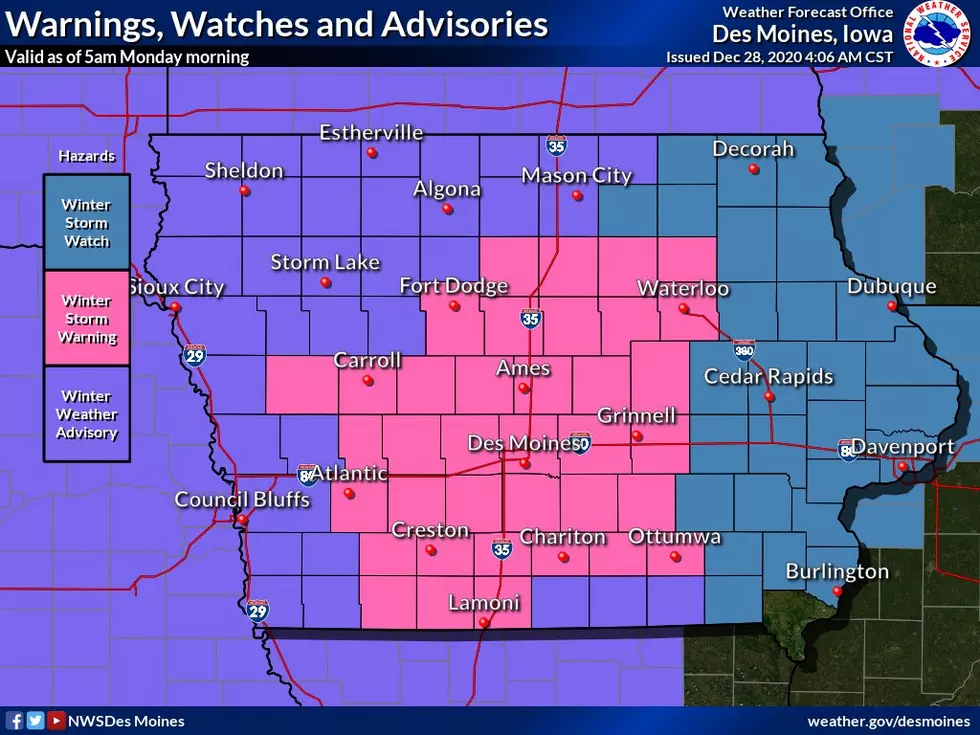
A Winter Storm Watch will be put into effect for 26 counties, including Dubuque, Linn, Jones, Jackson, Johnson, Cedar, Clinton, Muscatine, Scott, Keokuk, Washington, Louisa, Henry, IA, and Des Moines counties in Iowa, and Jo Daviess, Carroll,
Whiteside, Rock Island, and Mercer counties in Illinois.
The Winter Storm Watch will go into effect on Tuesday, December 29 at 12 p.m. until Wednesday, December 30 at 12 p.m.
According to the National Weather Service of the Quad Cities, a winter storm is expected to spread snow over the area on Tuesday afternoon. Snow is expected to become heavy at times through Tuesday night, especially along and north of a Fairfield, IA to Quad Cities, to Sterling, IL line.
Officials say that at this time, it appears 3 to 8 inches of snow is likely to fall along and north of that line.
South of that line from Fairfield, IA to the Quad Cities and Sterling, IL, snow will change to a mix of snow, sleet, and freezing rain Tuesday evening and overnight.
Officials say that travel is expected to become slick and difficult Tuesday afternoon through Wednesday morning.
A Winter Storm Warning has been issued for 37 counties in Iowa that will runs from 9 a.m. Tuesday to 6 a.m. Wednesday. Counties that will be under the Winter Storm Warning are expected to see snow fall totals in the range of 4-8" or more.
What's the difference between a Winter Storm Watch and Winter Storm Warning?
A winter storm watch is issued to provide 12 to 36 hours advance notice of the possibility of severe winter weather. A watch is upgraded to a Winter Storm Warning when 6" of snow or sleet is expected in the next 12 hours, or 8" or more in 24 hours, or sleet of 1/2" or more is expected.
Essential Winter Emergency Kit Items
More From ESPN 104.1 FM and 1170AM